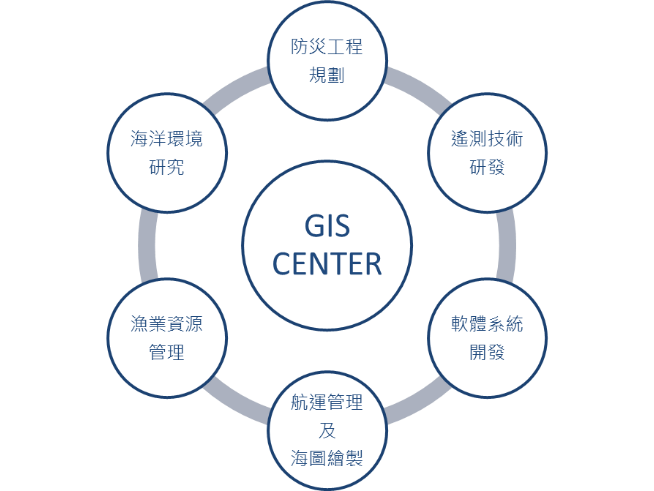
地理資訊系統研究中心之任務乃在結合地理資訊系統專家(包含計算技術、遙測、通訊、資料處理、空間分析、影像辨識等技術)以及領域專家(漁業科學、海洋科學、防災工程、航運管理、地質科學、人文社會科學等學門),從事相關實務應用之研究。
在漁業及海洋面向,透過衛星遙測技術即時探測大範圍海洋表面溫度、葉綠素濃度及水位高度等資料,持續推動衛星遙測資料建構及人員技術培訓,應用暨解明許多重要水產資源海洋學與重要經濟物種(鮪、烏魚、燈火漁業等)之漁況預報,進而發展成為本校重點研究之一。
在航運管理面向,加強整合地理資訊系統、全球衛星定位系統、自動識別系統(AIS)、行動運算、資料探勘與雲端運算等多項先進之空間資訊與通訊技術,提供政府部門及船運相關產業,全方位的智慧管理方案。在水利防災面向,因應流域整體治理規劃,持續研究開發水文及水理相關理論技術,強化開放原始碼地理資訊系統之應用,發展網際網路地理資訊系統(Web-GIS)技術,進而針對政府部門及防災相關產業,依據規劃分析、災防應用等不同需求面向,提供相關規劃應用工具及即時演算分析產品。
Mission of GIS Research Center It combines geographic information system experts (including computing technology, telemetry, communication, data processing, spatial analysis, image recognition, etc.) and domain experts (fishery science, marine science, disaster prevention engineering, shipping management, geological science, humanities and social sciences, etc School), engaged in research on related practical applications.
In fisheries and marineThrough satellite telemetry technology, real-time detection of large-scale sea surface temperature, chlorophyll concentration, water level and other data, continue to promote the construction of satellite telemetry data and personnel technical training, apply and explain the oceanography of many important aquatic resources and important economic species (tuna, mullet) , Denghuo fishery, etc.), and then developed into one of the key researches of our school.
In shipping management, to strengthen the integration of geographic information system, global satellite positioning system, automatic identification system (AIS), mobile computing, data mining and cloud computing and other advanced spatial information and communication technologies to provide government departments and shipping-related industries with all-round wisdom Management scheme. In terms of water conservancy and disaster prevention, in response to the overall management plan of the river basin, continue to research and develop hydrology and water related theory and technology, strengthen the application of open source geographic information system, develop Internet geographic information system (Web-GIS) technology, and then target government departments And disaster prevention-related industries, according to the different needs of planning analysis, disaster prevention applications, etc., provide relevant planning application tools and real-time calculation analysis products.