National Taiwan Ocean University

為落實國土資訊調查及防救災運用規劃,營建署推動「雨水下水道普查」。同時配合雨水下水道規劃及治理之推動,以普查成果為基礎,導入街道/下水道SWMM模式(包含雨水下水道、街道排水、區域排水等都市排水系統)建置方式,針對現況都市排水進行水理分析及檢討規劃,進而提供都市溢淹示警的加值應用。


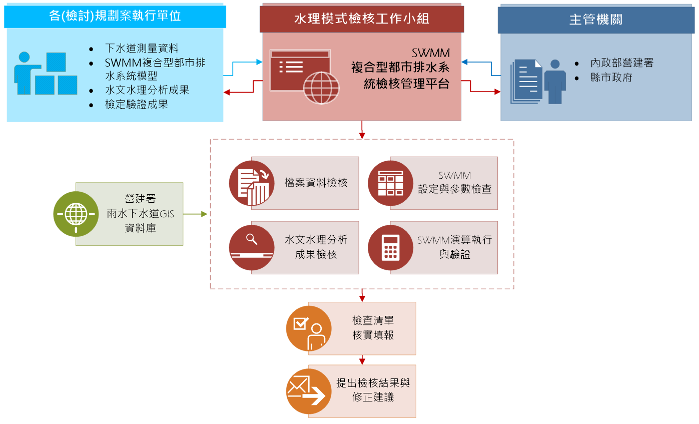
本中心協助提出街道/下水道SWMM模式建置標準作業流程,使雨水下水道(檢討)規劃案執行單位可配合辦理;同時透過一系列的檢核程序,確認水理模式的正確性,以此有效整合各縣市雨水下水道(檢討)規劃案成果。此外,本中心建置「SWMM複合型都市排水系統檢核管理平臺」,利用雲端技術,以網頁方式提供資料傳遞、清單檢查、檢核進度查詢等服務;並提供自主檢查功能,即可自行檢視水理模型的正確性。


In order to implement land information survey and disaster prevention and relief utilization plan, Construction and Construction Department promotes "Stormwater Sewer Census". At the same time, in cooperation with the promotion of stormwater sewer planning and governance, based on the results of the census, the street/sewer SWMM model (including stormwater sewers, street drainage, regional drainage and other urban drainage systems) construction methods are introduced to conduct hydraulic analysis and analysis of the current urban drainage. Review the planning, and then provide value-added applications for urban flood warning.


GIS center assists in proposing the standard operating procedure for the construction of the street/sewer SWMM model, so that the stormwater sewer (review) planning project execution unit can cooperate with it; at the same time, through a series of inspection procedures, confirm the correctness of the water management model, so as to effectively integrate The results of the stormwater sewerage (review) planning projects in various counties and cities. In addition, GIS center has built the "SWMM Composite Urban Drainage System Inspection and Management Platform", which uses cloud technology to provide services such as data transmission, checklist inspection, and inspection progress query through web pages; The correctness of the hydraulic model.

聯絡資訊Contact information

基隆市中正區北寧路2號
No.2, Beining Rd., Jhongjheng District, Keelung, Tawan 20224 (R.O.C.)
+886-2-2462-2192 分機:6163

國立臺灣海洋大學地理資訊系統研究中心 版權所有 © 2022 ALL Rights Reserved