和平溪、南澳溪及花蓮溪流域
水文與水力蘊藏量分析整合資訊平台
Ping Creek, Nan'ao Creek and Hualien Creek Basins Integrated information platform for hydrological and hydraulic reserves analysis
委託單位:台灣電力股份有限公司
Client: Taipower
【 研究背景 】
近年來,再生能源(renewable energy)已成為全球能源產業主流,而水力能源為再生能源之一,藉由水力發電開發計畫及水工設施維護管理,將可有效推廣水力發電並提高發電效能。由於水力發電與開發區位流域之地形、水文、水理等特性相關,故需因應地文與水文環境變遷,檢視各地區水力蘊藏量分布,適切調整管理維護方法,並確保現有水力發電設施穩定運轉。同時若能充分掌握與分析水文資訊,適時提供相關管理單位,預作必要因應措施,將可降低天然災害造成之損失。
【 執行成果 】
●水文與水力蘊藏量分析整合資訊平台架構
本計畫平台架構如圖1所示,主要包含「使用者本機端」、「系統伺服器端」及「測站資訊同步端」。「使用者本機端」應用軟體包括:(1)系統應用資料庫;(2)核心計算模組;(3)QGIS計算系統等。「系統伺服器端」主要工作為系統維護與更新,連線伺服器主機則採用台灣電力公司內現有伺服器。「測站資訊同步端」位於台電公司對外伺服器,主要工作為透過網際網路取得水利署及中央氣象局之測站的最新參數,以確保使用水文觀測資料庫測站資料之正確性。
【 Research Background 】
In recent years, renewable energy has become the mainstream of the global energy industry, and hydropower is one of the renewable energy sources. Hydropower development plans and maintenance and management of hydraulic facilities will effectively promote hydropower and improve power generation efficiency. Since hydropower generation is related to the topography, hydrology, and hydrological characteristics of the development area, it is necessary to review the distribution of hydropower reserves in each region in response to changes in the geography and hydrology environment, adjust management and maintenance methods appropriately, and ensure the stable operation of existing hydropower facilities. . At the same time, if we can fully grasp and analyze the hydrological information, timely provide relevant management units, and take necessary countermeasures in advance, the losses caused by natural disasters will be reduced.
【 Implementation results 】
●Hydrology and hydraulic reserves analysis integration information platform architecture
The platform structure of this project is shown in Figure 1, which mainly includes "user local terminal", "system server terminal" and "measuring station information synchronization terminal". "User's local terminal" application software includes: (1) system application database; (2) core computing module; (3) QGIS computing system, etc. The main work of the "system server side" is system maintenance and update, and the connection server host adopts the existing server of Taiwan Power Company. The "Station Information Synchronization Terminal" is located on the external server of Taipower Corporation. Its main job is to obtain the latest parameters of the stations of the Water Resources Department and the Central Meteorological Bureau through the Internet to ensure the correctness of the station data used in the hydrological observation database.
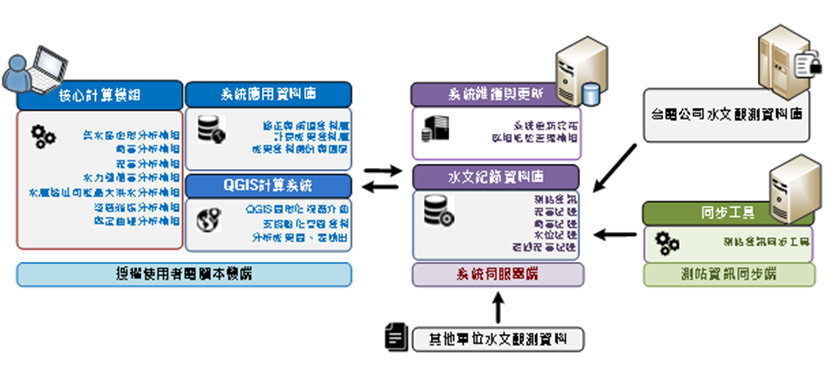
圖1 水文與水力蘊藏量分析系統架構圖
Architecture diagram of hydrology and hydraulic reserves analysis system
本計畫以QGIS為開發平台,可提供使用者完善的地理資訊系統操作環境,以針對水文與水力蘊藏量分析整合資訊平台之計算成果,配合數化圖層資料作進一步之空間分析。本計畫以QGIS官方2019年釋出之QGIS 3.4版進行模組功能開發,以此提供眾多空間分析工具與優質之GIS操作環境。
●水力蘊藏量分析
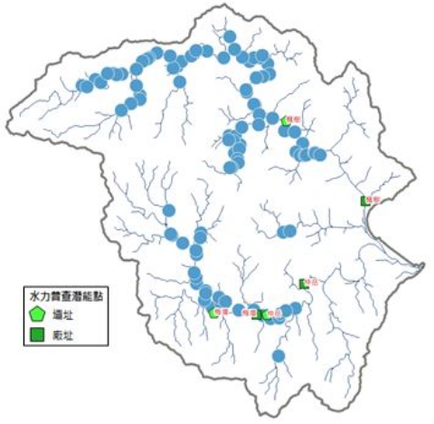
「水力蘊藏量分析」提供流域內河川網路上任一位置點之面性及線性水力蘊藏量資訊,並可針對特定堰壩址位置進行水力蘊藏量計算。由於南澳溪流域包含重要遊憩區範圍,工程開發受到管制,因此對於水力發電壩址之選定,首先排除南澳遊憩區點位,同時排除山崩地滑地質敏感區。圖2為南澳溪流域經排除限制開發區後,以川流方式進行發電廠址選定,依照水力蘊藏量排序前1000處的計算成果。由於鄰近河段之水力蘊藏量甚為接近,因此將可開發堰址位置及其水力蘊藏量進行叢集分析(cluster analysis),故鄰近河段中水力蘊藏量相近的堰址位置,可視為相同類群,則可分為100群。而後,將各群中最大電力的堰址作為代表處,共100處(如圖3),再針對南澳溪流域的可開發水力發電堰址,以單位成本排序,藉以優選出最佳水力發電可能堰址。
This project uses QGIS as the development platform, which can provide users with a complete geographic information system operating environment, and integrate the calculation results of the information platform for hydrological and hydraulic reserve analysis, and further spatial analysis with digitized layer data. This project uses the QGIS 3.4 version officially released by QGIS in 2019 for module function development, so as to provide many spatial analysis tools and a high-quality GIS operating environment.
●Hydraulic Reserve Analysis
"Hydraulic reserve analysis" provides areal and linear hydraulic reserve information at any point on the river network in the basin, and can calculate the hydraulic reserve for a specific dam site. Since the Nan'ao Creek Basin includes important recreational areas, project development is subject to control, so for the selection of hydropower dam sites, the Nan'ao recreational area points are first excluded, and the geologically sensitive areas of landslides and landslides are excluded at the same time. Figure 2 shows the calculation results of selecting the power plant sites in the stream method after excluding the restricted development zone in the Nan'ao River Basin, and sorting the top 1,000 sites according to the hydraulic reserves. Since the hydraulic reserves of adjacent river sections are very close, cluster analysis is performed on the position of the developable weir sites and their hydraulic reserves. Therefore, the locations of weir sites with similar hydraulic reserves in adjacent river sections can be regarded as the same group, and can be divided into For 100 groups. Then, take the weir site with the largest power in each group as the representative site, a total of 100 sites (as shown in Figure 3), and then sort the developable hydropower weir sites in the Nan'ao River Basin by unit cost, so as to optimize the best possible hydropower generation weir address.
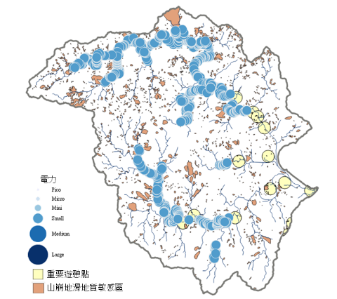
圖2 南澳溪流域水力蘊藏量前1000處空間分布(川流方式)
Spatial distribution of the top 1000 hydropower reserves in the Nan'ao River Basin (river flow mode)
圖3 南澳溪流域水力蘊藏量叢集分析結果之最大電力代表處(川流方式)
The largest power representative point of the cluster analysis results of hydraulic reserves in the Nan'ao River Basin (river method)
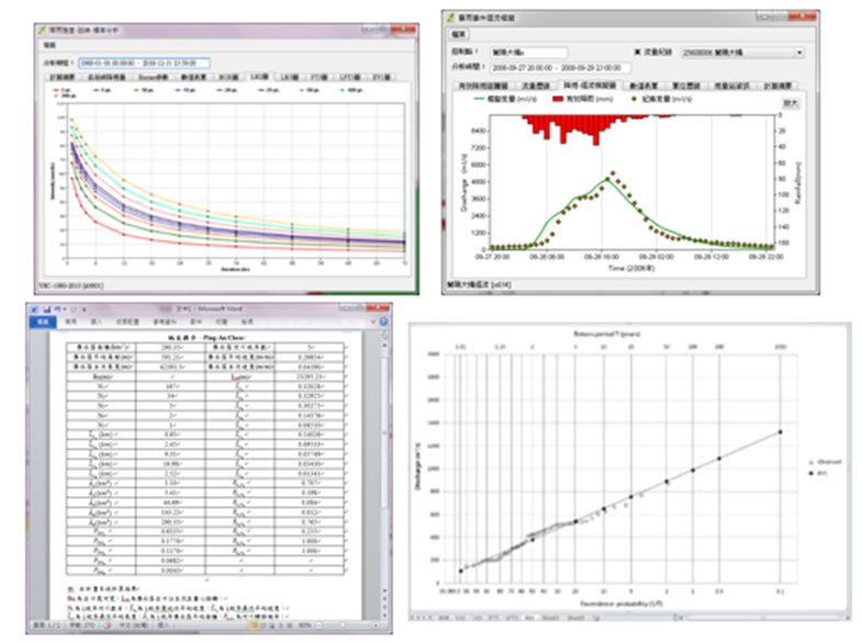
●分析成果輸出
連結『分析模組』之水文與水理模式演算成果,以圖、表方式展示演算成果,其客製化之報表輸出功能,可自動產生數值表單、頻率分析機率點繪圖,以及常用之EXCEL或WORD報表(如圖4)。
●Analysis result output
Link the hydrological and hydrological model calculation results of the "Analysis Module", and display the calculation results in the form of graphs and tables. Its customized report output function can automatically generate numerical tables, frequency analysis probability point plots, and commonly used EXCEL or WORD report (as shown in Figure 4).
圖4 分析成果輸出展示畫面
Analysis result output display screen
●雲端系統功能建置
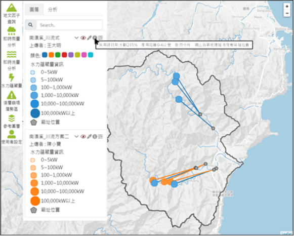
「水文與水力蘊藏量資訊雲端系統」登入後之主畫面如圖5所示,本系統主要可提供和平溪、南澳溪、花蓮溪及秀姑巒溪等流域之即時水情與水力蘊藏量資訊。主要功能包含基礎圖資瀏覽、地文因子查詢、即時雨量分析、即時流量分析、水力蘊藏量資訊上傳與查詢、即時淺層崩塌潛勢區域分析等功能,並介接政府開放平台之地圖圖磚服務,提供使用者套疊使用;於「個人設定」中提供個人書籤依個人需求進行頁籤設定。
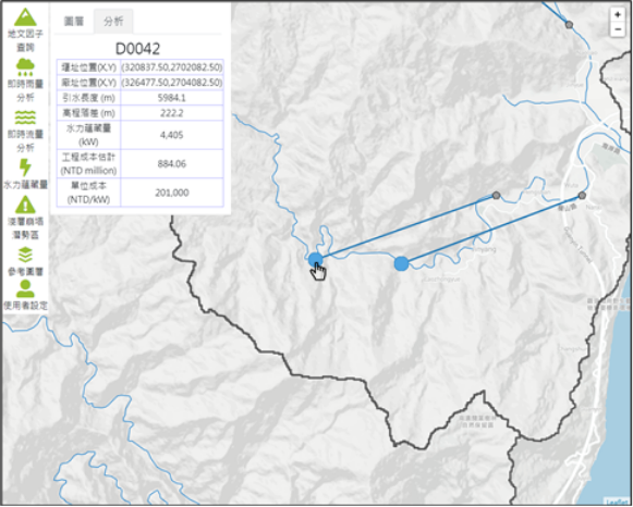
「水文與水力蘊藏量分析整合平台」可提供使用者進行水力蘊藏量成果上傳,並於「成果資訊設定」介面輸入於雲端系統欲顯示之方案名稱、上傳者,以及方案描述,而後即可上傳相關空間圖資。待圖資上傳完畢後,雲端系統左側將顯示目前伺服器上所有上傳成果(如圖6),使用者可選擇選單內圖資加入於地圖區中,並提供使用者顏色切換功能,以提高不同方案同時呈現之辨識度。另外,使用者可點擊堰址位置查詢該堰址之水力蘊藏量發電資訊(如圖7),透過多人成果共享之方式,可提高計算成果之應用性。
●Cloud system function construction
The main screen of the "Hydrological and Hydraulic Reserve Information Cloud System" after logging in is shown in Figure 5. This system mainly provides real-time water regime and hydraulic reserve information of Pingxi, Nan'ao, Hualien and Xiuguluan Rivers and other river basins . The main functions include browsing of basic map data, query of geographical factors, real-time rainfall analysis, real-time flow analysis, upload and query of hydraulic reserve information, real-time analysis of shallow collapse potential areas, etc., and interface with map tiles of the government open platform Service, which provides users with nested use; provides personal bookmarks in "Personal Settings" to set tabs according to individual needs.
The "Hydrological and Hydraulic Reserve Analysis Integration Platform" allows users to upload hydraulic reserve results, and enter the name of the project to be displayed in the cloud system, the uploader, and the project description in the "Result Information Setting" interface, and then upload Related spatial maps. After the uploading of map data is completed, all the uploaded results on the current server will be displayed on the left side of the cloud system (as shown in Figure 6). Users can select the map data in the menu to add to the map area, and provide the user with a color switching function to improve the difference. The recognition of the scheme presented at the same time. In addition, the user can click on the location of the weir site to query the power generation information of the hydropower reserves of the weir site (as shown in Figure 7). Through the sharing of results by multiple people, the applicability of the calculation results can be improved.
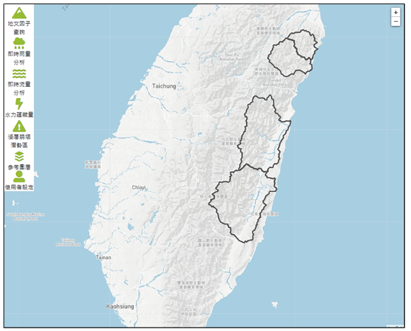
圖5 「水文與水力蘊藏量資訊雲端系統」主畫面
Main screen of "Hydrology and Hydraulic Reserve Information Cloud System"
圖6 「水文與水力蘊藏量資訊雲端系統」主畫面
Main screen of "Hydrology and Hydraulic Reserve Information Cloud System"
圖7 水力蘊藏量查詢功能
Hydraulic reserve query function