【 研究背景 】
為延續政策推動執行,本計畫配合營建署「前瞻基礎建設計畫-水環境建設計畫-水與安全-縣市管河川及區域排水整體改善計畫-下水道及都市區其他排水」執行,延續前期計畫的街道/下水道SWMM模式檢核作業,並將各案件檢核成果應用至營建署「都市溢淹示警系統」,期可將既往以鄉鎮市區為警戒發布單位,逐案提升為以都市計畫區的街廓為警戒發布單位,藉此提供更為精確的溢淹地點。
【 研究目的 】
本計畫將延用前期計畫「都市防災示警系統水位監測與預警分析作業建置計畫」方法,針對各核定補助雨水下水道(檢討)規劃案中,所建置的街道/下水道SWMM模式進行檢核作業,並持續建置街廓溢淹指標資訊,以期將範圍擴及全臺各地雨水下水道,而達到颱風豪雨期間能準確提供參考資訊之目的。計畫中亦將針對兩大系統平臺進行功能擴充與維護作業,以達到符合使用者需求以及系統問題排除等目的。另外計畫中每年均辦理模式建置相關軟體基礎操作教學,全期教育訓練總量至少為15天150人,以使營建署及各縣市政府得有能力自行建置街道/下水道SWMM模式,並作模式基本調校及維護。
【 執行成果 】
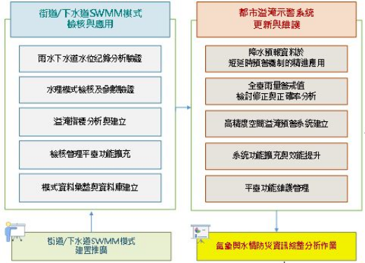
●整體計畫構想與工作流程
(1)複合型都市排水系統水理模式檢核及參數驗證
(2)複合型都市排水系統街廓溢淹指標分析
(3)「SWMM複合型都市排水系統檢核管理平臺」功能調整應用與維護作業
(4)水位及災情紀錄介接分析與已核定水理模式校核維護作業
(5)複合型都市排水系統模式建置推廣
(6)短延時強降雨預警機制加強評估
(7)氣象及水情防災資訊綜整分析作業等工作
【 Research Background 】
In order to continue to promote the implementation of the policy, this plan is implemented in conjunction with the "Prospective Infrastructure Construction Design-Water Environment Construction Design-Water and Safety-County and City Management River and Regional Drainage Overall Improvement Plan-Sewer and other drainage in urban areas" of the Construction and Construction Department. Continuing the pre-planned street/sewer SWMM model inspection operation, and applying the inspection results of each case to the "Urban Flood Warning System" of the Construction and Construction Department, it is expected that the previous warning release units in townships and urban areas can be upgraded to case-by-case The street outline of the urban planning area is used as the warning release unit to provide a more accurate flood location.
【 Research purposes 】
This project will continue to use the method of the previous project "Urban Disaster Prevention and Warning System Water Level Monitoring and Early Warning Analysis Operation Construction Plan", and carry out the construction of the street/sewer SWMM model for each approved subsidy stormwater sewer (review) planning project Check the operation, and continue to build the street overflow index information, in order to expand the scope to the stormwater sewers in all parts of Taiwan, and achieve the purpose of providing accurate reference information during typhoons and heavy rains. The plan will also carry out function expansion and maintenance operations for the two major system platforms, in order to meet user needs and eliminate system problems. In addition, in the plan, the basic operation teaching of model construction related software will be conducted every year, and the total amount of education and training in the whole period will be at least 15 days for 150 people, so that the construction department and the county and city governments will have the ability to build the street/sewer SWMM model by themselves. And do basic mode adjustment and maintenance.
【 Implementation results 】
●Overall project conception and workflow
(1)Hydrological Model Check and Parameter Validation of Composite Urban Drainage System
(2)Analysis of street profile overflow index in compound urban drainage system
(3)"SWMM Composite Urban Drainage System Inspection and Management Platform" function adjustment application and maintenance operations
(4)Interconnection analysis of water level and disaster records and verification and maintenance of approved water management models
(5)Construction and promotion of composite urban drainage system model
(6)Enhanced evaluation of short-delay heavy rainfall early warning mechanism
(7)Comprehensive analysis of meteorological and water disaster prevention information, etc.
圖1 計畫工作主軸與工作重點
Plan work main axis and work focus
●複合型都市排水系統水理模式檢核作業&辦理水理模式建置與檢核說明會
計畫中針對各(檢討)規劃案執行單位所提出的複合型都市排水系統水理模式,進行下列四階段檢核作業(如圖9):
(1)第一階段:檔案資料檢核
(2)第二階段:SWMM模式設定與參數檢查
(3)第三階段:水文水理分析成果檢核
(4)第四階段:SWMM模式演算執行與驗證
並針對每次的檢核作業提供檢核成果與修正建議。
另外,為使執行單位能夠熟悉檢核流程,並加速檢核作業。計畫中以專案服務方式辦理複合型都市排水系統模式建置說明與諮詢服務,由各執行顧問公司指派實際SWMM模組建置人員參與會議。會議中說明相關檢核作業程序、模式建置修正與檢核意見、模式建置常見問題與討論等,以提升各執行顧問公司對複合型都市排水模式建置的瞭解。
●Composite Urban Drainage System Water Management Model Inspection Operation & Handling Water Management Model Construction and Inspection Explanation Session
In the plan, the following four-stage inspection operations are carried out for the water management model of the composite urban drainage system proposed by the implementing units of each (review) plan (as shown in Figure 9):
(1)Stage 1: Checking of files and data
(2)The second stage: SWMM mode setting and parameter checking
(3)The third stage: checking of hydrological and hydraulic analysis results
(4)The fourth stage: SWMM model calculation execution and verification
And provide inspection results and correction suggestions for each inspection operation.
In addition, in order to enable the execution unit to be familiar with the inspection process and speed up the inspection operation. In the plan, construction instructions and consulting services for the complex urban drainage system will be handled in the form of project services, and the actual SWMM module construction personnel will be assigned by each executive consulting company to participate in the meeting. In the meeting, the relevant inspection procedures, revisions and inspection opinions on model establishment, common problems and discussions on model establishment, etc. were explained in order to enhance the understanding of each executive consultant company on the establishment of a composite urban drainage model.
圖2 水理模式檢核成果與修正建議示意
Hydrological model verification results and correction suggestions
●「SWMM複合型都市排水系統檢核管理平臺」功能新增
本計畫因應營建署業務需求,除維持「SWMM複合型都市排水系統檢核管理平臺」既有功能正常操作外,並持續增設平臺相關水理檢核輔助功能。而目前已完成的系統功能(如圖3)說明如下:
(1)水理檢核自動化程式功能:可針對EPA-SWMM 5.1以上版本數值模型檔,全區「自動化檢查」雨水竣工管線尺寸、雨水竣工人孔(含虛人孔)尺寸、測量成果(雨水下水道GIS屬性表)是否一致;並可針對街道側溝尺寸、偏移量設定,以及街道節點參數進行確認,以提供各(檢討)規劃執行單位自行檢查使用。
(2)各(檢討)規劃案件水理檢核進度控管作業功能:依據四階段水理檢核作業,控管各階段資料補正上傳次數,以確認各階段水理檢核作業時程,有效管控並提升執行單位與檢核團隊的工作進度。
(3)SWMM模式建置正確率分析功能:針對模式中雨水下水道排水系統(人孔、下水道幹管)、街道排水系統、明渠排水系統、及都市次集水區等參數設定,進行檢核後的正確率分析計算;並將該結果呈現於檢核報表欄位中,作為驗收審核的參考依據。
●"SWMM Composite Urban Drainage System Inspection and Management Platform" function added
In response to the business needs of the Construction and Construction Department, this plan not only maintains the normal operation of the existing functions of the "SWMM Composite Urban Drainage System Inspection and Management Platform", but also continues to add auxiliary functions related to water physical inspection on the platform. The currently completed system functions (as shown in Figure 3) are described as follows:
(1)Water physical inspection automation program function: for EPA-SWMM version 5.1 and above numerical model files, "automatically inspect" the size of the completed rainwater pipeline, the size of the completed rainwater manhole (including virtual manhole), and the measurement results (rainwater sewer GIS attributes) Table) is consistent; and can be confirmed for the street side ditch size, offset setting, and street node parameters, so as to provide each (review) planning implementation unit for self-check.
(2)Each (review) planning case hydraulic inspection progress control operation function: According to the four-stage hydraulic inspection operation, control the number of data corrections and uploads at each stage to confirm the time schedule of each stage hydraulic inspection operation, effectively control and improve The work progress of the execution unit and the inspection team.
(3)Correct rate analysis function of SWMM model construction: for the parameter setting of rainwater sewer drainage system (manhole, sewer main pipe), street drainage system, open channel drainage system, and urban sub-catchment area in the model, the correct rate after checking Analyze and calculate; and present the result in the check report column as a reference for acceptance review.
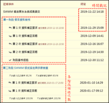
圖3 「SWMM複合型都市排水系統檢核管理平臺」新增功能
"SWMM Composite Urban Drainage System Inspection and Management Platform" New Functions
●水位紀錄檔上傳系統
為能有效進行水位紀錄介接工作,計畫中乃建置「水位紀錄檔上傳系統」(如圖4),以提供水位紀錄介接上傳使用。透過「水位紀錄檔上傳系統」新增水位站的監測點位資訊,再將欲上傳的檔案,直接拖曳至系統頁面的上傳區,或點選「選擇檔案」按鈕進行選取。若單一檔案選取錯誤,可點選上傳區檔案後方「取消」按鈕,用以取消選取;或是可點選上傳區上方「全部取消」按鈕,來取消已選取的所有檔案。確認選取檔案無誤後,可點選上傳區檔案後方「上傳」按鈕,個別上傳檔案;或是點選上傳區上方「全部上傳」按鈕,用以批次上傳所有已選取的檔案(如圖4)。
●Water level record file upload system
In order to effectively carry out the interface work of water level records, the plan is to build a "water level record file upload system" (as shown in Figure 4) to provide interface uploading of water level records. Add the monitoring point information of the water level station through the "Water Level Record File Upload System", and then drag the file to be uploaded directly to the upload area of the system page, or click the "Select File" button to select. If a single file is selected incorrectly, you can click the "Cancel" button behind the file in the upload area to cancel the selection; or you can click the "Cancel All" button above the upload area to cancel all the selected files. After confirming that the selected files are correct, you can click the "Upload" button behind the files in the upload area to upload individual files; or click the "Upload All" button above the upload area to upload all selected files in batches (as shown in Figure 4) .
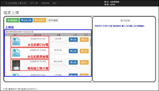
圖4 水位監測資料庫系統功能架構
Functional Architecture of Water Level Monitoring Database System
●「都市溢淹示警系統」功能擴充
(1) 累積雨量與重現期對應關係圖
為加強短延時強降雨預警機制評估結果,將全臺322個鄉(鎮、市、區)於30、60、90、120分鐘情況下,不同重現期(2年、5年、10年、25年、50年、100年、200年)所對應降雨量(mm)的參考表,匯入「都市溢淹示警系統」資料庫,以提供累積雨量與重現期對應關係圖的繪製功能使用。
使用者使用「都市溢淹示警系統」時,可透過地圖介面點擊特定鄉(鎮、市、區),開啟該鄉(鎮、市、區)的資訊介面,於「現況各延時重現期」頁面查詢該鄉(鎮、市、區)的累積降雨量與雨量重現期的對應關係圖(如圖4)。因此,透過本功能可快速得知目前即時累積降雨的重現期,以作為判斷降雨強度的依據。
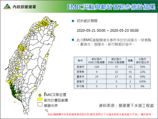
(2) 都市計畫區EMIC警訊統計報表
於中央應變中心開設期間,為因應營建署執勤業務臨時需求,乃針對全臺各都市計畫區的積淹水災情狀況,進行即時初步評估與統計作業。取得全臺災點(篩選災情類別為「積淹水災情」的統計資訊)坐標位置,並與都市計畫區範圍圖進行套疊,進而統計出都市計畫區內的積淹水災情災點數量,與積淹水災情災點於都市計畫區內的比例,以供值勤人員進行初步評估。
統計報表內的資訊包含EMIC災點所在縣市地區、都市計畫區內外的災點個數與總數統計,以及災點於都市計畫區內比例統計數據,藉此資訊讓使用者快速判斷評估各都市計畫區的積淹水災情受災狀況(如圖5)。
●Functional expansion of "Urban Flood Warning System"
(1) Corresponding relationship between accumulated rainfall and return period
In order to strengthen the evaluation results of the short-time-delay heavy rainfall early warning mechanism, 322 townships (towns, cities, districts) in Taiwan were compared with 30, 60, 90, and 120 minutes for different return periods (2 years, 5 years, 10 years, The reference table of rainfall (mm) corresponding to 25 years, 50 years, 100 years, and 200 years) is imported into the database of "urban flood warning system" to provide the function of drawing the corresponding relationship between accumulated rainfall and return period .
When users use the "Urban Flood Warning System", they can click on a specific township (town, city, district) through the map interface to open the information interface of the township (town, city, district), and click on the "Delayed recurrence period of the current situation" On the page, query the correspondence relationship between the cumulative rainfall and the rainfall return period of the township (town, city, district) (as shown in Figure 4). Therefore, through this function, the return period of the current real-time accumulated rainfall can be quickly known, which can be used as a basis for judging the rainfall intensity.
(2) Statistical report of EMIC alarm signal in urban planning area
During the opening of the Central Emergency Response Center, in response to the temporary needs of the Construction and Construction Agency's on-duty business, an immediate preliminary assessment and statistical operation was carried out on the flooding disaster situation in various urban planning areas throughout Taiwan. Obtain the coordinates of the disaster points in Taiwan (filter the statistical information of the disaster category as "flooding disaster"), and overlap with the map of the urban planning area, and then count the flooding disaster points in the urban planning area The quantity and the proportion of the flooded disaster points in the urban planning area are for the duty personnel to conduct a preliminary assessment.
The information in the statistical report includes the counties and cities where the EMIC disasters are located, the number and total statistics of the disasters inside and outside the urban planning area, and the statistical data on the proportion of disasters in the urban planning area. This information allows users to quickly judge and evaluate The status of flooding disasters in each urban planning area (as shown in Figure 5).
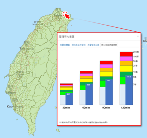
圖5 累積雨量與重現期對應關係
Correspondence between accumulated rainfall and return period
圖6 都市計畫區EMIC災點統計分析報表
Statistical Analysis Report of EMIC Disaster Points in Urban Planning Area