【 研究背景 】
臺灣處在有利於漁業發展的地理位置,加上氣候與水文條件的配合,充滿多樣性的沿近海漁業逐漸成為重要的初級產業。然而,隨著台灣沿近海域污染情形日益嚴重、兩岸漁船數過多且漁獲效率日益提升、全球環境變遷等因素衝擊下,漁業資源呈明顯衰退現象。考量民眾對沿近海漁業之水產品需求,須根據觀測、模擬與分析技術,以建立燈火漁業生物資源的預報系統,並提供適時的預報資訊。
【 研究目的 】
本計畫為達成強化海象科技研發、促進海象科技民生應用之政策目標,藉由觀測補強與技術開發之執行策略,達到建立發布科技民生應用的作業能力,期能提升或滿足未來民眾和漁業產業單位之需求。
中央氣象局已發展出高解析度的作業化海流系統,目前這些作業化的海流模式對於大尺度與中短期的預測均有相當高的準確性,但海洋生物多屬冷血性動物,其分布與洄游模式亦受到水溫效應的影響,由於海象變化具有高度的不確定性,前述海流模式在漁業生物的預測顯然不足,由於中央氣象局已在臺灣環島建置波浪與潮位觀測系統,整合與應用中央氣象局於近海浮標增加水文環境監測儀器,並納入廣海域遙測水溫觀測的多變量機率預測理論是一種可行的方法。
【 執行成果 】
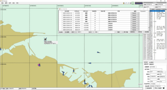
(1)應用現有船舶自動識別系統(AIS),發展即時海溫與海洋相關環境資料之即時資料傳輸至漁船或岸台的技術。
(2)藉由篩選的歷史颱風,蒐集其颱風中心位置與路徑資料,與其對應集水區的逐時觀測雨量資料;
(3)應用OCM海溫、海流及葉綠素資料發展Octave程式之漁況模式與海象模式。
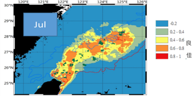
(4)改善臺灣東北部棲地模式準確度,並提供過去3年漁場資料。
(5)臺灣西南部火誘網漁場漁海況建立,結合中央氣象局提供之湧升流與海流模式及海洋相關環境資料,評估燈火漁業之棲地模式可行性,並提供過去3年漁場資料。
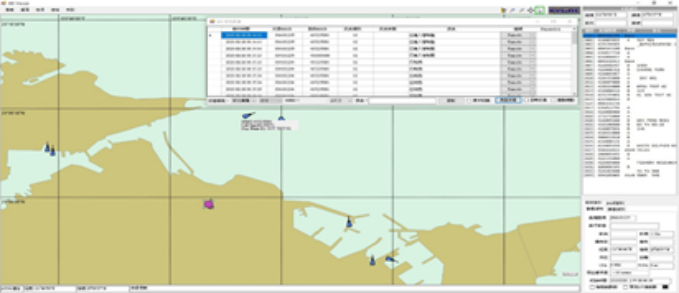
(6)設計、改善開發「臺灣海象災防環境資訊平台-近海漁場海況」之展示介面。
(7)臺灣海峽海表水溫鋒面系統建置方法研究與建立,建立衛星遙測海表水溫鋒面邊緣偵測法(Objective edge-detection algorithm)。
【 Research Background 】
Taiwan is located in a geographical location that is conducive to the development of fisheries. Coupled with the cooperation of climate and hydrological conditions, the coastal and coastal fishery full of diversity has gradually become an important primary industry. However, with the increasingly serious pollution of Taiwan's coastal waters, the excessive number of fishing boats on both sides of the strait and the increasing fishing efficiency, and the impact of global environmental changes, fishery resources have shown a significant decline. Considering the public's demand for aquatic products from coastal fisheries, it is necessary to establish a forecast system for the biological resources of the light fishery based on observation, simulation and analysis techniques, and provide timely forecast information.
【 Research purposes 】
This plan aims to achieve the policy goals of strengthening the research and development of walrus technology and promoting the application of walrus technology to people's livelihood. Through the implementation strategy of observation reinforcement and technology development, it can establish the operational ability to release technology and people's livelihood applications, hoping to improve or meet the needs of the future public and the fishery industry. unit needs.
The Central Meteorological Administration has developed a high-resolution operational ocean current system. Currently, these operational ocean current models are quite accurate for large-scale and short-term predictions. However, most marine organisms are cold-blooded animals, and their distribution is closely related to Migration models are also affected by water temperature effects. Due to the high degree of uncertainty in walrus changes, the aforementioned ocean current models are obviously insufficient in predicting fishery organisms. Since the Central Meteorological Administration has established a wave and tide level observation system around the island in Taiwan, integration and application It is a feasible method for the Central Meteorological Administration to add hydrological environment monitoring instruments to offshore buoys and incorporate the multivariable probability prediction theory of telemetry water temperature observations in wide sea areas.
【 Implementation results 】
(1)Apply the existing automatic identification system (AIS) to develop the technology of real-time sea temperature and ocean-related environmental data transmission to fishing boats or shore stations.
(2)Based on the selected historical typhoons, the location and track data of the typhoon center and the hourly observed rainfall data of the corresponding catchment area are collected;
(3)Using OCM sea temperature, ocean currents and chlorophyll data to develop the Octave program's fishing model and walrus model.
(4)Improve the accuracy of habitat models in northeastern Taiwan and provide fishery data for the past 3 years.
(5)The fishing and sea conditions of the fire lure net fishing ground in southwestern Taiwan were established. Combined with the upwelling and current patterns and marine related environmental data provided by the Central Meteorological Bureau, the feasibility of the habitat model of the light fishing industry was evaluated, and the fishery data of the past 3 years were provided.
(6)Design, improve and develop the display interface of "Taiwan Walrus Disaster Prevention Environmental Information Platform - Sea State of Offshore Fishing Grounds".
(7)Research and establishment of the sea surface water temperature front system construction method in the Taiwan Strait, and establish the objective edge-detection algorithm of the satellite telemetry sea surface water temperature front edge.
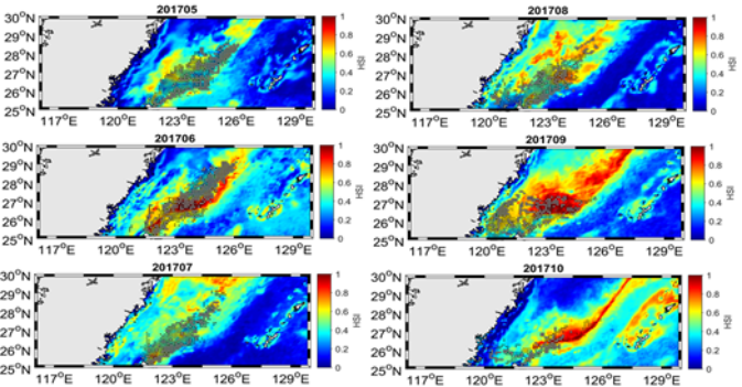
圖1 東北海域燈火漁業鎖管漁場月別海況變動產品
Products of monthly sea state changes in the lighting fishery lock pipe fishing ground in the Northeast Sea
圖2「燈火漁業漁場海況」模組之展示介面及相關預報產品
The display interface and related forecast products of the "Lighting Fishery Fishing Ground Sea State" module
圖3 將AIS整合應用於「燈火漁業漁場海況」模組之案例
A case of integrating AIS into the module of "Lighting Fishery Fishing Ground Sea State"