聲納技術重建壩體水下3D數位影像
量測與可行性研究
Underwater 3D digital image measurement and feasibility study of reconstruction of dam body by sonar technology
委託單位:中央氣象局
Client: Central Weather Bureau
【 研究背景 】
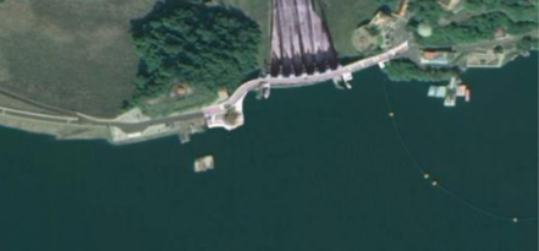
本計畫運用多波束測深儀與側掃聲納等聲納量測相關技術,針對石門水庫發電進水口、排砂隧道進水口、永久河道進水口及壩體等範圍(如圖23)進行量測,並進行聲納量測原始資料後處理作業,以建立石門水庫壩體水下結構與淤積現況3D數位影像。
【 Research Background 】
This plan uses sonar measurement technologies such as multi-beam depth sounder and side-scan sonar to measure the water inlet of Shimen Reservoir for power generation, the water inlet of the sand discharge tunnel, the water inlet of the permanent river channel and the dam body (as shown in Figure 23). and carry out post-processing of the raw data of the sonar measurement to establish a 3D digital image of the underwater structure and sedimentation status of the Shimen Reservoir dam.
圖1 石門水庫聲納量測作業位置圖
Shimen Reservoir sonar survey operation location map
【 研究目的 】
進行水下3D數位影像建置,以利進行水下應變處置作業,並助於瞭解隱蔽部分之真實結構。協助水下作業(如抽泥、閘門前淤積清除拆裝)等潛水作業之研發需求,期望如下
(1) 強化水下作業人員安全,降低作業風險
(2) 提升水下作業效能
(3) 減少原龐大之作業及維護費用。
【 執行成果 】
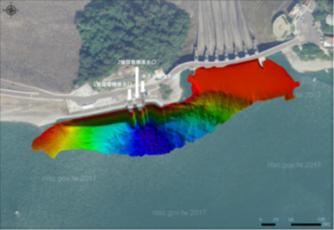
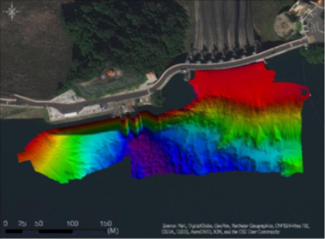
本計畫今年度進行二次石門水庫水下量測實測。量測完成後產出水深點雲資料、多波束測深資料、側掃聲納資料。圖24為石門水庫大壩多波束測深結果。
由測量結果顯示今年兩次量測差異性不大,推估可能為相距時間太近,且無環境變動影響(如:颱風)。
【 Research purposes 】
Underwater 3D digital image construction is carried out to facilitate underwater emergency response operations and help understand the real structure of hidden parts. Assist in the research and development needs of diving operations such as underwater operations (such as mud pumping, sediment removal and disassembly in front of the gate), and the expectations are as follows
(1) Strengthen the safety of underwater operators and reduce operational risks
(2) Improve the efficiency of underwater operations
(3) Reduce the original huge operation and maintenance costs.
【 Implementation results 】
This plan will carry out the second underwater measurement and measurement of Shimen Reservoir this year. After the measurement is completed, water depth point cloud data, multi-beam bathymetric data, and side-scan sonar data will be produced. Figure 24 shows the results of multi-beam sounding for the Shimen Reservoir Dam.
The measurement results show that there is not much difference between the two measurements this year. It may be estimated that the time interval is too close and there is no environmental change (such as: typhoon).
圖2 多波束測深結果(上圖為第一次,下圖為第二次)
Multi-beam sounding results (the picture above is the first time, and the picture below is the second time)