【 研究背景 】
港口為船隻停泊的地點,其交通的順暢性也影響著船隻的作業,而經過時間的變遷,海底地形會因各種外在因素而改變,進而產生危險,卻因水體的遮蔽而無法直接以肉眼察覺,故本案期以長潭里漁港為例,對漁港水底掃描結果進行分析。
【 研究目的 】
本計畫針對鄰近重要港口設施海岸地形,利用3D水下掃描技術,進行水下海岸地形變遷之監測調查。進行時首次量測描繪以船裝載量測設備,依實際條件選用合適之設備(例如單波束、多音束、側掃儀器)針對長潭里港區掃描。針對特定區位進行選點確認後,再以人工方式進行細部監測。
【 執行成果 】
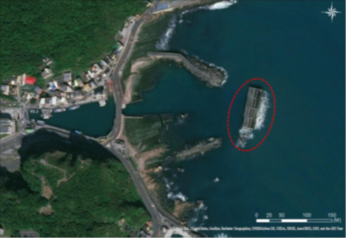
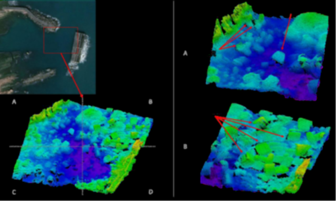
本計畫針對堤防(如圖1)進行掃描,並判斷該設施是否有變形、破損或是有沉積物覆蓋等現象。探測成果(如圖2)所示,港外離岸堤及港口防坡堤皆有清晰影像,由成果影像可得知,各結構物表面並未有明顯破損之情形。
【 Research Background 】
The port is a place where ships berth, and the smoothness of its traffic also affects the operation of the ship. Over time, the topography of the seabed will change due to various external factors, which will cause danger. Therefore, this case takes Changtanli Fishing Port as an example to analyze the bottom scanning results of the fishing port.
【 Research purposes 】
This project uses 3D underwater scanning technology to monitor and survey the changes of underwater coastal topography for the coastal topography adjacent to important port facilities. During the first measurement and depiction, the measurement equipment is loaded on the ship, and the appropriate equipment (such as single beam, multi-sound beam, side-scanning instrument) is selected according to the actual conditions to scan the Changtanli port area. After the point selection is confirmed for a specific location, detailed monitoring is carried out manually.
【 Implementation results 】
This project scans the embankment (as shown in Figure 1) and judges whether the facility is deformed, damaged or covered with sediment. As shown in the detection results (Figure 2), there are clear images of the offshore dikes outside the harbor and the port breakwaters. From the results, it can be seen that there is no obvious damage to the surface of each structure.
圖1 離岸堤位置圖
Offshore Embankment Location Map
根據上一年度之探測成果發現(如圖3),離岸堤與港口堤防間有疑似沉箱、消波塊及礁石等航行障礙物散佈於航道,各障礙物尺寸由1~4公尺不等。為維護港區航行安全及掌握結構物損壞情形,本年度使用更高精密度之多音束測深儀,針對上一年度探測之經驗,規劃及著重加強探究消波塊分佈之密度、散落情形以及針對重點懷疑部分進行正常淤積或是非正常物質堆積並將結果呈現。
本計畫建議後續能夠搭配堤防(結構物)之原始設計圖比較防波堤及港內外現況達到更為有效之檢視及排查問題根源。除此之外規劃高密度探測測線與長期追踪,以進一步探究消波塊分布密度、散落情形與來源等資訊,供後續相關研究及工程施作之參考。
According to the detection results of the previous year (as shown in Figure 3), there are suspected caissons, wave-absorbing blocks and reefs scattered in the channel between the offshore embankment and the port embankment, and the size of each obstacle ranges from 1 to 4 meters. . In order to maintain the safety of navigation in the port area and grasp the damage of structures, a higher-precision multi-beam echo sounder was used this year. Based on the experience of the previous year's detection, it was planned and focused on strengthening the exploration of the density of the distribution of wave-absorbing blocks, the scattering situation, and the The key suspected parts are normal sedimentation or abnormal material accumulation and the results will be presented.
This plan suggests that in the future, the original design drawings of the embankment (structure) can be used to compare the breakwater and the current situation inside and outside the port to achieve more effective inspection and troubleshooting. In addition, high-density detection and survey lines and long-term tracking are planned to further explore information such as the distribution density of wave-absorbing blocks, scattered conditions, and sources, for reference in subsequent related research and engineering construction.
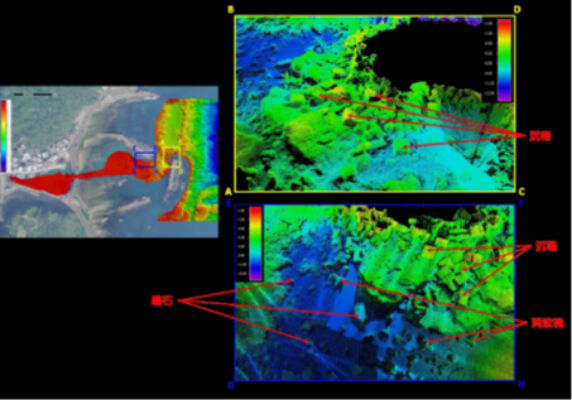
圖2 多音束3D點雲成果(109年度)
Multi-sound beam 3D point cloud achievement (109 years)
圖3 多音束3D點雲成果(108年度)
Multi-sound beam 3D point cloud achievement (108 years)