【 研究背景 】
近年來,國內於都會區進行相關基地保水、減洪、滯蓄設施設置,期以增加都會區的減洪能力。然而,台灣降雨空間分布差異甚大,滯蓄設施設計過程需要取用正確的降雨紀錄分析成果,配合規劃地點之地文與水文特性,並考慮建築基地下游排水系統之通洪能力,方能達成正確且有效的配置規劃。若能透過一整合型分析工具,協助建築從業人員執行雨水滯蓄設施規劃設計之相關工作,並提供相關主管單位直接線上檢視相關設計成果資訊之功能,將可縮短相關審查作業之時間,從而提升工作效率。
【 研究目的 】
目前國內尚無其它針對雨水滯蓄設施之容量配置規劃,建立整合型雲端計算系統。而為提供一便捷之計算工具,並使計算成果能合於實際情況,本計畫採用Web-GIS技術建立雲端計算操作系統,系統除可自動擷取分析計算所需之空間參數外,亦可考慮多種設施間之複合型規劃。本計畫將持續進行系統功能擴充與操作介面之優化,並舉辦專家座談會與推廣說明會,使建築從業人員能以快速且簡易之方式,瞭解本系統之功能與應用方式,並透過本系統之實際應用與操作,協助提升執行相關規劃設計工作之效率。
【 執行成果 】
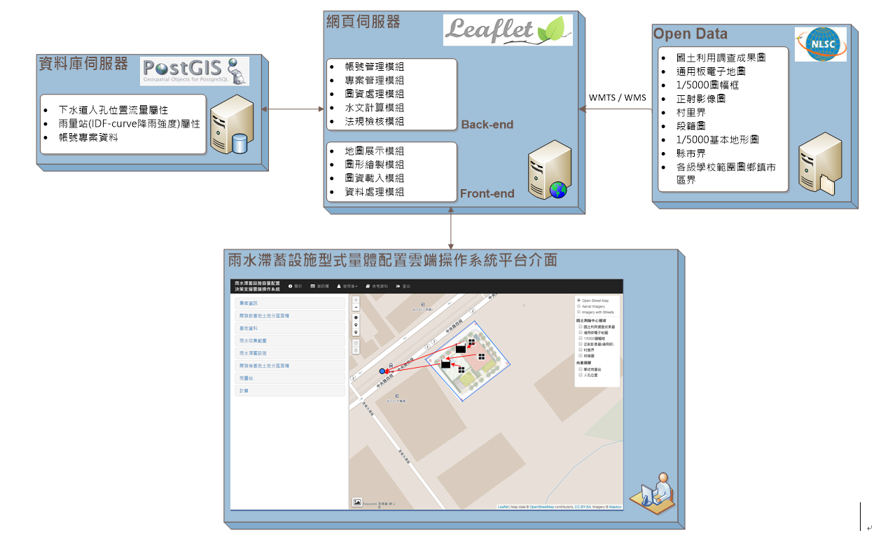
●Web-GIS雲端操作系統架構
本雲端操作系統平台架構(如圖1),依功能可分為網站系統與檢核系統兩部分。網站系統之主要功能為提供使用者透過瀏覽器,進行滯蓄設施規劃設計。另亦介接內政部國土測繪中心Open Data圖資,供使用者於規劃設計之參考。檢核系統是將滯蓄設施設計之水文分析成果進行相關法規檢核,並同時以網頁與報表之方式呈現檢核結果。
【 Research Background 】
In recent years, China has set up related bases for water conservation, flood reduction, and storage facilities in metropolitan areas in order to increase the flood mitigation capacity of metropolitan areas. However, the spatial distribution of rainfall in Taiwan is very different. The design process of storage facilities needs to use the correct analysis results of rainfall records, cooperate with the geographical and hydrological characteristics of the planning site, and consider the flood drainage capacity of the downstream drainage system of the construction base to achieve the correct result. And effective configuration planning. If an integrated analysis tool can be used to assist construction practitioners in the planning and design of rainwater storage facilities, and provide the relevant competent authorities with the function of directly viewing the relevant design results online, the time for related review operations will be shortened, thereby improving work efficiency.
【 Research purposes 】
At present, there is no other capacity allocation plan for rainwater stagnation storage facilities in China to establish an integrated cloud computing system. In order to provide a convenient calculation tool and make the calculation results in line with the actual situation, this project uses Web-GIS technology to establish a cloud computing operating system. In addition to automatically extracting the spatial parameters required for analysis and calculation, the system can also Consider composite planning among multiple facilities. This project will continue to expand system functions and optimize the operation interface, and hold expert forums and promotion briefings, so that construction practitioners can understand the functions and applications of this system in a fast and easy way, and through this system The practical application and operation of the system help to improve the efficiency of the implementation of related planning and design work.
【 Implementation results 】
●Web-GIS cloud operating system architecture
The cloud operating system platform architecture (as shown in Figure 1) can be divided into two parts, the website system and the verification system, according to functions. The main function of the website system is to provide users with the planning and design of storage facilities through a browser. In addition, it also connects to the Open Data map data of the National Land Surveying and Mapping Center of the Ministry of the Interior for users' reference in planning and design. The checking system is to check the hydrological analysis results of the design of the stagnant storage facilities for relevant laws and regulations, and present the checking results in the form of web pages and reports at the same time.
圖1 系統架構示意圖
System Architecture Diagram
●雲端系統擴充
本計畫蒐集國內外最新雨水滯蓄設施(含低衝擊開發技術、基地保水、雨水貯留利用、貯集滯洪等相關技術)容量配置、實際案例、技術規範、雲端操作系統以及逕流分擔、出流管制等相關資料進行彙整研析,並擴充以新北市全區為研究範圍,考量各種基地開發類型情況,進行系統功能增修;配合流域綜合治理政策,擴充雨水滯蓄設施Web-GIS雲端系統如圖2,新增出流管制計算機制,藉此考慮開發基地周圍雨水下水道、區域排水系統之允許排放量。並新增複合式基地運算功能,並進行雨水滯蓄設施雲端系統之操作介面功能優化作業。
●Cloud System Expansion
This project collects the latest domestic and foreign rainwater storage facilities (including low-impact development technology, base water conservation, rainwater storage and utilization, storage and detention and other related technologies) capacity configuration, actual cases, technical specifications, cloud operating system, and runoff sharing and outflow Collect and analyze related data such as control, and expand the research scope to the whole area of New Taipei City, consider the development types of various bases, and carry out system function enhancement; cooperate with the comprehensive management policy of the river basin, expand the rainwater storage facilities Web-GIS cloud system such as Figure 2, a new outflow control calculation mechanism is added to consider the allowable discharge of rainwater sewers and regional drainage systems around the development base. Added a composite base calculation function, and optimized the operation interface function of the cloud system for rainwater storage facilities.
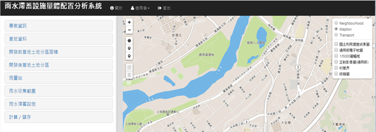
圖2 雨水滯蓄設施Web-GIS雲端系統
Rainwater storage facilities Web-GIS cloud system