台灣地區重要河川流域水文與水理設計分析系統平台建立
Establishment of hydrological and hydraulic design and analysis system platform for important river basins in Taiwan
委託單位:經濟部水利署水利規劃試驗所
Client: Water Resources Planning Institute
【 研究背景 】
近年全球氣候異常,頻繁引發水文極端現象,全台因颱風、豪雨所造成受災範圍與程度均遠較過去劇烈,實有待進一步整合新近水文紀錄資料與河川斷面資料,重新進行分析演算,以獲得可靠之規劃設計資訊;先前以商業軟體ArcView建置地文與水文分析功能,雖可藉由互動式界面提高工作效率,但軟體費用昂貴及軟體版本維護困難,故需建置一開放式軟體分析系統平台。
【 研究目的 】
開發水文與水理設計分析功能,同時採用開放原始碼地理資訊系統(open source GIS)架構,配合系統應用資料庫與網路更新功能,利用最新量測之數值高程資料,建置「台灣地區重要河川流域水文與水理設計分析系統平台」,提供水利相關人員一套完整而便捷的分析工具。
【 執行成果 】
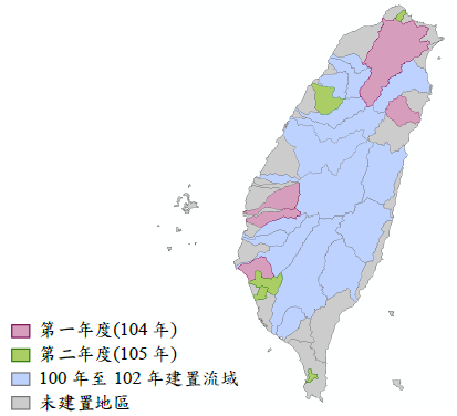
●執行流域範圍
第一年度( 104年)建置淡水河、北港溪、朴子溪、鹽水溪及和平溪流域,第二年度( 105年)建置磺溪、後龍溪、二仁溪、阿公店溪及四重溪流域(如圖1),應用最新數值高程資料,建置數值高程模式,並完成流域下游平坦地河川網路擷取之修正,以更新地文計算功能;另採用開放原始碼地理資訊系統建置水文水理計算平台與整合,並提供系統功能新增與擴充服務。
【 Research Background 】
In recent years, global climate anomalies have frequently caused hydrological extremes. The scope and degree of disasters caused by typhoons and heavy rains in Taiwan are far more severe than in the past. It is necessary to further integrate the latest hydrological record data and river cross-section data, and re-analyze calculations to obtain Reliable planning and design information; previous geography and hydrology analysis functions were built with the commercial software ArcView. Although the work efficiency can be improved through the interactive interface, the software cost is expensive and the software version maintenance is difficult, so an open software analysis system needs to be built platform.
【 Research purposes 】
Develop the hydrological and hydraulic design analysis function, and adopt the open source geographic information system (open source GIS) framework, cooperate with the system application database and network update function, and use the latest measured numerical elevation data to build the "Taiwan area important "River Basin Hydrology and Hydraulic Design Analysis System Platform" provides a set of complete and convenient analysis tools for water conservancy personnel.
【 Implementation results 】
●Execution Basin Scope
In the first year (104 years), the watersheds of Danshui River, Beigang River, Puzi River, Saltwater River and Ping River were built, and in the second year (105 years), Sulfur River, Houlong River, Erren River, Agongdian River and Sichong River were built For the watershed (as shown in Figure 1), use the latest numerical elevation data to build a numerical elevation model, and complete the correction of the flat river network capture in the lower reaches of the watershed to update the geography calculation function; in addition, use the open source code geographic information system to build Hydrological and hydraulic computing platform and integration, and provide system function addition and expansion services.
圖1 計畫執行流域範圍
Plan implementation catchment scope
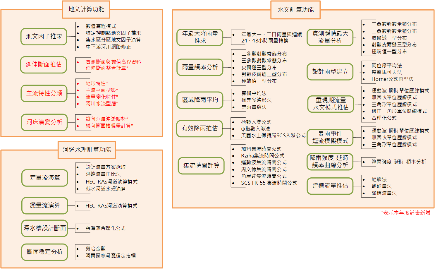
●水文與水理分析系統功能
「台灣地區重要河川流域水文與水理設計分析系統平台」為一整合地文、水文、水理等計算程式之分析軟體。主要分析功能模組可分為「地文計算功能」、「水文計算功能」及「河道水理計算功能」三大部分(如圖2)。
●Functions of hydrological and hydraulic analysis system
The "Hydrological and Hydraulic Design Analysis System Platform for Important River Basins in Taiwan" is an analysis software that integrates geography, hydrology, and hydraulic calculation programs. The main analysis function modules can be divided into three parts: "terrestrial calculation function", "hydrological calculation function" and "river hydrology calculation function" (as shown in Figure 2).
圖2 水文與水理設計分析系統功能
Functions of hydrological and hydraulic design analysis system